 |
History of the town
The settlement of Shirakawan, sometimes spelt Shirakavan, and also known by its older name of Erazgavorz, developed into a small town in the mid-ninth century AD. It was located about 25km Northeast of Ani. The Bagratids had a royal residence there from the late 800s, and Shirakawan served as their capital until it was transferred to Ani. The town is also known to have had a fortress. The town got its name from Shirak, the name of the province of Armenia in which it was situated.
Shirakawan was sacked by the Seljuk Turks in the 1060s but was rebuilt during the Zakarid period at the end of the 12th century.
By the 19th century it had declined into a small, Armenian-populated village called Bashsuregel, (sometimes rendered as Bach-Chouraguel and spelt Başsüregel on some Turkish maps). Today the site is inside Turkish territory - however, part of it may now lie under the waters of the Arpa/Akhurian dam. On modern maps the village of Çetindurak seems to lie closest to the site.
The Holy Amenap'rkitch church
in Shirakawan
The St. Amenap'rkitch (Holy Saviour of All) church was commissioned by the Bagratid King Smbat I. The date construction started was probably after 892 (the year of Smbat's coronation) and 893 (when an earthquake is known to have struck the town). Catholicos Yovhanness wrote in his "History of Armenia" that the church in Shirakawan was consecrated shortly after his elevation to the patriarchal throne (which took place in 897/898), and that it was located near the royal palace.
An inscription on its walls mentioned that restoration work was undertaken between 1072 and 1081.
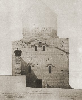
At a later date the church was converted into a fortified tower. During this conversion the eastern niches and many of the windows were filled in, and the corners of the church were heightened. An external staircase was also added at the northern end of the west façade.
The dome of the church had collapsed by the 19th century. Nikolai Marr ¹ noted the remains of the polygonal drum of the original dome. That dome had collapsed at a distant period and had been replaced by a conical dome with a smaller diameter. The replacement dome had also mostly collapsed and had been replaced by a covering of wooden beams that were, by 1913, rotten and about to fail.
Marr wrote that in 1913 the building was undergoing repairs and was being converted into the village's parish church. He mentions that during those repairs the villagers had dug up many architectural fragments, but none had been recorded and most had just been reused in new buildings. He also mentions "two magnificent capitals" that had been recovered by the villagers and were now stored inside the church.
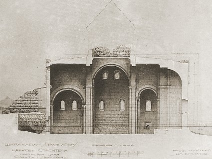
In 1914 the architect N. Bouniatov undertook a detailed measured survey of the Shirakawan church, producing a plan, elevations, cross-sections, and drawings illustrating some of its architectural details. Below are two of Bouniatov's drawings: a cross-section along the nave, and a depiction of the west facade.
The Shirakawan church is said to have been still intact until the 1950s, when it was intentionally destroyed.
Architectural analysis
The church had a rather archaic "domed-hall" plan that was similar to examples dating from the 7th century (such as Aruch). Other archaic features included having three windows in the apse. Side chambers with semicircular east walls flanked the apse. The church as designed was well-lit, with numerous large windows. The drum of the dome was supported on pendentives. Design advances included the dihedral niches on the north and south facades, as well as on the more usual east facade. The church sat on a wide, five-stepped base.
On its walls was a mixture of archaic and contemporary decorative motifs. The tops of the dihedral niches were intricately decorated and were similar to those on the church at Oğuzlu (which probably dates from the 890s). Marr saw a Georgian influence in the decoration around the twin window frames and the relief cross on the south façade. He postulated that this was because the Shirakavan church dated from before the emergence of the "Ani school" of architecture, to a time when the Armenian and Georgian architectural styles were more closely related. He wrote that although Shirakawan was located close to Ani, "centuries separate the architecture of Ani from the religious buildings of Shirakawan".
Other monuments in Shirakawan
Marr mentions that to the south of the St. Amenap'rkitch church the villagers of Shirakawan had uncovered the remains of a well-built wall clad in finely finished ashlar stone. Marr postulated that it probably was a part of the palace of the Bagratid kings, or that it was composed of materials removed from the site of that palace.
According to an 1878 report ², in the northern section of the village there was a dilapidated chapel called "Barjreal", and in the north-eastern section of the village were the ruins of two more churches. Marr mentions a ruined cruciform church known as "Ballu-kilissa" that was located to the east of the cathedral.
Marr also mentions a chapel on a hill to the north of the village. The 1878 report, probably describing the same place, says that on a hill to the north of the village were the remains of a monastery whose walls contained inscriptions in Armenian. The same report records that half an hour walking distance to the north were old ruins and tombs at a site called Khartash and, close by, in the village of Aralig / Arpalik, were the ruins of a monastery and tombs. Persians inhabited Aralig, according to the report.
Marr wrote that in 1913, at the southern end of the hill with the chapel (which is the same hill on which the Tignis fortress stands), peasants had discovered pagan tombs containing burial objects, including a sword hilt, a fibula, and a decorated belt.
NOTES:
1. Marr, Nikolai Yakovevich, Ani, Knizhnaya istoriya goroda i raskopki na meste gorodishcha (Ani, Literary history of the city and the excavations of the site of the ancient city), Leningrad and Moscow, 1934, chapter 11.
2. The report is summarised in Monasteries, Churches, and Fortresses in the Region of Kars (The Status Quo in 1878) in Armenian Architecture: A Documented Photo-Archival Collection on Microfiche, volumes 6.
PAGE HISTORY:
5th November 2006 - This webpage is first published
21st May 2008 - Architectural drawings by Bouniatov added, the plan of the church ammended (windows added) to match that of Bouniatov's survey.
|
|
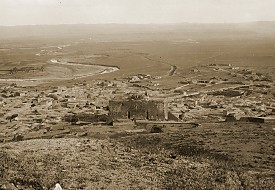
1. Bashsuregel village, former Shirakawan, at the start of the 20th century - click for a larger photo

2. Shirakawan's St. Amenap'rkitch church seen
from the Southeast - click for a larger photo
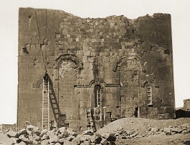
3. The east facade of the church
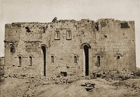
4. The south facade - click for a larger photo
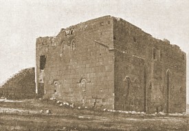
5. The church seen from the Southwest
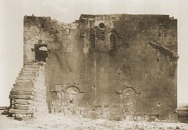
6. The west facade of the church

7. Inside the church, looking west from the apse
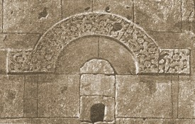
8. A hooded moulding above one of the windows
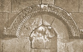
9. A hooded moulding above one of the windows
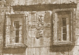
10. The twin windows on the south facade
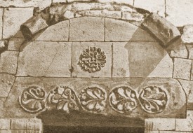
11. The lintel over the south entrance

12. People standing in front of the south entrance
|