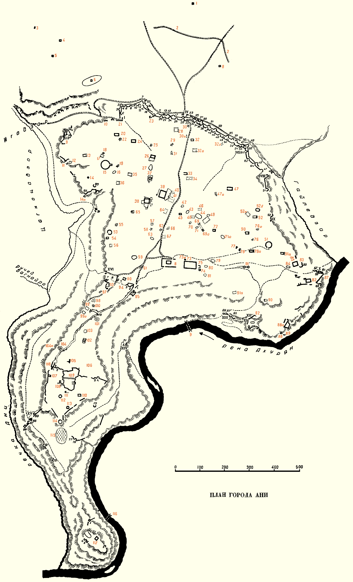
Outside the Walls
Inside the Walls
The Old City (within King Ashot's walls)
The Citadel
Kizkale Peninsula
1 Ruins of a bathhouse
2 Ramparts
3 Tumulus of ruins
4 Mausoleum of Kirakos 5 Ruins of a chapel 6 Ruins of a chapel 7 Rock-cut church 8 Ruins of a church
9 Palace known as "the Baron's palace" 10 Church with a voluted capital 11 Rock-cut Church 12 Unidentified Ruins 13 Ruins of a palace 14 Oil Press 14a Underground room 15 Church of St. Gregory of King Gagik (the Gagikashen) 16 Tumulus 17 Palace of Sargis 18 Oil Press 19 Oil Press 20 Ruins of a large church 21 Site with tunnels 22 Oil Press 23 Baths 24 Church of Bakhtakegi (excavated in 1892) 25 Oil Press 26 Church known as the "Georgian Church" 27 Ruins of a refuse pit 28 Tower of Minuchihir 29 Oil Press 30 Oil Press 31 Oil Press 32 Ruins of an unidentified building 32a Unidentified ruins 32b Oil Press 33 Ruins of a church 34 Ruins of a church 35 Probable ruins of a church 36 Unidentified ruins 37 Building with 4 columns (the firetemple) later converted to a church 38 Church of the Holy Apostles 39 Hostelries (excavated in 1908) 40 The "red church" 41 Two large rooms 42 Tumulus 43 Tumulus 44 Tumulus 45 Ruins of a church 46 Ruins of a church with rich decoration in wood 47 Ruins of a church 47a Oil press 48 Baths 49 Tumulus 50 Church decorated with checkerboard pattern 51 Church of the Holy Redeemer 51a Ruins of a church 52 Ruins of a church 52a Unidentified ruins 52b Tumulus 53 Church of St. Gregory of the Abughamirs' 54 Ruins of buildings 55 Oil Press 56 Ruins of a church with a khatchk'ar 57 Ruins of a structure with four corners 58 Oil Press 59 Multiple tumulus 60 Church of Horom Tikin 61 Oil Press 62 Minaret of the mosque of Abu'l Muamran 63 Tumulus 64 Unidentified ruins 65 Oil Press 66 Multiple tumulus 67 Ruins of churches 68 Residence of a prelate 69-69a Columnaded gallery 70 Tumulus 71 Tumulus 72 St. Sarkis church 73 Cathedral of Ani 73a House with a wall in a checkerboard pattern (excavated in 1908) 74 Baptistry of cathedral 75 Mausoleum of Queen Katranideh 76 Oil Press 76a Oil Press 77 Tower connected to a vaulted passageway 78 Tower connected to an underground passageway 78a Church 79 Tumulus 80 Tumulus 81 Unidentified ruins 82 Church of St. Gregory of Tigran Honents 83 Baths (excavated in 1893) 84 Tumulus 85 Vaulted gallery 86 Oil Press 87 Entry to an underground room 88 Chapel beside the Akhurian river 88a Unidentified ruins 89 Guardhouse 90 Unidentified ruins 91 Unidentified ruins 91a Unidentified ruins 92 Monastery of the Virgins
93 A secular building 94 Wall of King Ashot 95 Mosque of Minuchihr (and museum of Ani) 96 Bridge 97 House with two rooms 98 Ruins of a church 99 Museum of Ani - subsidiary building 99a Site of the residence of Nikoli Marr's team 100 Oil press, and ruins of civil building 101 Church of K'arimadin, called "the red church" 102 Church of the Mother of God of Khambouchents 103 Tumulus 104 Church of Abu Khacib 104a One of the entries to the underground city 105 Mausoleum of Gayl 106 Church 107 Ruins of a 4 columned structure 108 Unidentified ruins
109 The royal palace 109a Palatine church 109b Hall in the royal palace 109c Hall in the royal palace 109d Hall in the royal palace 109e Baths in the royal palace 109f Cistern within the palace 110 Church of Mijnaberd 111 Vaulted structure 112 Tetraconch church 113 Church beside the citadel wall 114 Hexagonal church 115 Armenian Cemetery 118 Water conduit beside the gate to the city
116 Bridge of the Kamsarakan tower 117 Convent of St. Gregory of Aljkayberd
| THE PLAN OF ANI BY NIKOLAI MARR |
This plan is taken from the Russian book "Ani - a History of the City and its Excavations" by Nikolai Marr, Leningrad and Moscow, 1934. The plan had previously appeared in the 1910 "Little Guide to Ani" by Hovep Orbeli, published by the Ani Museum. It is an acceptably accurate plan - however, not every visible ruin site at Ani is marked on it. More recent surveys of Ani exist, but they have not been released to the public. Sites that are numbered in orange on the plan are listed in the index opposite. These "Marr/Orbeli" identification numbers (often abbreviated to "M.-O." or "M-O", for example "M-O 88") continue to be used by modern archaeologists. Numbers in black refer to individual towers within the city walls - numbers 1 to 95 for the outer walls, 1 to 7 for King Ashot's wall, 1 to 4 for the citadel, 1 to 4 for Kizkale. Main entry points through the city walls are identified with Roman numerals. I: Gate onto Igadzor valley. II + III: Kars gate, inner and outer walls. IV + V: Lion Gate, outer and inner walls. VI + VII: Chequerboard Gate, outer and inner walls. VIII: Gayladzor postern gate. IX: Gate onto Gayladzor valley. X: Gate of Aruch. XI + XII: postern gates. XIII: Gate of Sargis Cilench. XIV: Dvin Gate. XV: Gate of King Ashot. XVI: Gate onto Tsaghkotsadzor valley. |